
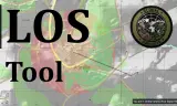
GC LOS is a map tool that lets players examine line of sight from a source point into a target area.
Players now
1
Servers
3
Rating
-
Subscribers
-
69 downloads
Busiest servers running it 3 in total
All servers
 Germany
1.8.0.13
Germany
1.8.0.13
 United States
1.8.0.13
United States
1.8.0.13
 Canada
1.8.0.13
Canada
1.8.0.13
Players on servers with it
daily, last 30 days
Details
- Author
- TilW
- Version
- 2.0.0
- Size
- 125 KB
- Licence
- APL
- Game version
- 1.8.0.13
- Likes
- 0 / 0 dislikes
- Published
- 5 Sep 2026
- Updated
- 2 weeks ago
- Workshop ID
- 6A4AF7AA127CC8A1
Recent adoption
30 days: +1 −0 ↑3
- ↑ COALITION Fight Club Dallas | One-life PvP Milsim | discord.gg/the-coalition 1.0.0 2.0.0 1w ago
- ↑ Global Conflicts | One Life Missions | discord.globalconflicts.net 1.0.0 2.0.0 2w ago
- ↑ W.T.A.F Milsim Conflict 1.0.0 2.0.0 2w ago
- + COALITION Fight Club Dallas | One-life PvP Milsim | discord.gg/the-coalition 1.0.0 2w ago
- − BH Gaming 1.0.0 1mo ago
Required by
5
Often used with
8






Version history
2-
v2.0.0 125 KB 25 Sep 2026
Complete rewrite of the mod
-
v1.0.0 118 KB 5 Sep 2026
Description from the Workshop
Usage: 1. On your map, activate the LOS tool on the left. 2. Click onto the map to select a source location. 3. Visibility from the source position will be indicated on the map via overlay. Features: - Switch between differrent visibility modes: While the default mode only darkens quads according to visibility, the "Colorize" will also differenciate between terrain (red) and object (yellow) occlusion. - Adjust the source and target height using the UI, they represent altitude above ground. E. g. you could do 1 and 25 to figure out where a low flying helicopter could avoid being seen by an anti aircraft gun. - Change the resolution multiplier to get a more or less detailed view (relative to zoom level) - high detail might take a while to fully calculate.